RVCA Drought Update
A message from RVCA's Senior Water Resources Technician, Patrick Larson:
I have meant to put together a summary of conditions in the watershed for awhile but have held off because I wanted to be able to report on a meeting the Conservation Authorities in Severe drought had asked for with Ministry of Natural Resources and Forestry. Unfortunately, it has taken longer than anticipated to come together and is now scheduled for the November 14th. So, a summary now and a report on the meeting after the 14th.
An average of 15.4 millimeters of rain fell in the first two weeks of October. An average of 75.4 mm fell in the next six days, most of that on the 20th through the 22nd. The good points about this rain event were that it was well distributed over the watershed and wasn’t intense rain that could have overwhelmed urban drainage systems. However, while there has been some rain since, it has not been enough to sustain flows so most streams have again declined. There needs to be enough regular rainfall to fill the wetlands and saturate the soil before streams can reach and stay close to historical averages. Now, as streamflows decline, the pattern of disconnected pools is occurring again. A concern is that what aquatic populations are left, after struggling to survive in the warm water, low oxygen and shrinking pools through the summer, are now faced with shallow pools that are going to freeze possibly solid.
Lakes in the watershed have also had increased levels from the rain with the reservoir lakes rising closer to targets. Bobs Lake is actually above target after a summer that was a trial for boaters as the water got lower and lower. The other three reservoir lakes are all below the respective targets. To put a bit of a positive spin on what has passed, there was water throughout the summer in all watershed lakes, just not what residents have been used to. Some farmers have had quite good crops from soybeans to apples. We have had only limited contact with people who have had their wells go dry and do not know what the present status is.
To close, with flows falling again, there is really no change in the rationale for the Severe Drought status that flows and levels have not been restored to normal. The one outlier is Kemptville Creek that received over 100 mm of rain and had levels at the Oxford Mills Dam rise a metre to summer target levels, just in time for the adjustment to winter levels. Flows have not declined as much as the rest of the watershed so, technically, that sub-watershed could have the drought status raised but it might be prudent to leave it and the rest of the Rideau watershed in Severe status so as to avoid confusion if conditions decline further.
Contact: 613-692-3571 or 1-800-267-3504 ext. 1210
Fire Ban Lifted for Tay Valley
The Fire Ban for Tay Valley Township has been officially lifted. Please ensure that you obtain Fire Permits from the Municipal Office for all burning with the exception of small supervised campfires. These permits are FREE and good for life. Each time you burn, call the number at the bottom of the permit (613-267-2596), choose extension #2, and follow the prompts.
The DNETV Fire Rescue Department and Tay Valley Municipal Office would like to remind everyone that all burning should be continuously supervised, and that a source of water be accessible at all times to assist in preventing out of control fires.
For the latest 24-hour Fire Ban information, please contact the Fire Department Administration Office directly at 613-267-2596, and listen to the automated message.
End of Season Operations on the Rideau Canal
Click here to read the Parks Canada Information Bulletin regarding the closing of the Rideau Canal lockstations for the season, effective October 11, 2016.
Season Closing for Colonel By Island
Due to infrastructure improvements, Parks Canada closed Colonel By Island for the season, effective September 29th. Island access and all facilities, including docks, will be unavailable as of this date.
Masonry repairs at Narrows Lock beginning in October
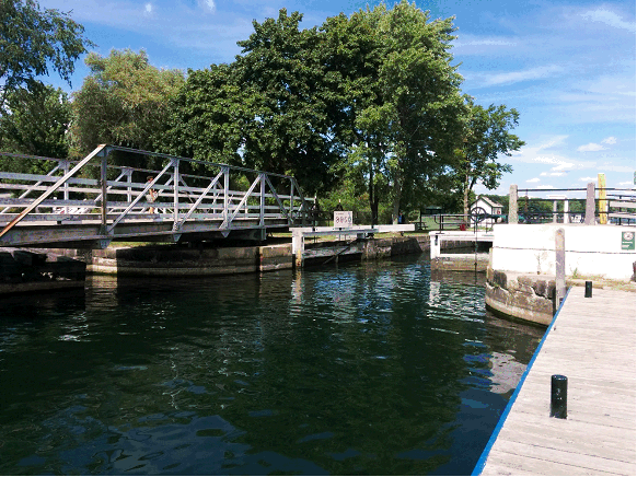
Parks Canada has issued the following news release about work beginning soon at Narrows Lock:
In October 2016, Parks Canada will begin heritage masonry repair work at Narrows Lock 35 located on the Rideau Canal National Historic Site. Stone replacement, grouting and repointing will be completed to ensure the continued structural integrity and functionality of the lock. Some of the repairs will occur below the swing bridge, requiring the bridge to be shifted to open position for their completion. Once complete, the swing bridge will be winterized for preservation.
This work will cause intermittent delays and a potential for nightly closures of County Road 14 at Narrows swing bridge. Road closures are tentatively planned for the end of November. In order to reduce impact to the public, road closures have been planned during times with lower volumes of traffic. Final dates and details will be made public, as soon as they have been confirmed.
This project is part of Parks Canada’s unprecedented $3 billion dollar investment over 5 years to support infrastructure work to heritage, visitor, waterway and highway assets located within national historic sites, national parks, and national marine conservation areas across Canada. These historic investments will mitigate health and safety risks, halt the loss of nationally significant built heritage and stimulate the economy in communities across the country.
Alternate Driving Route
Once County Road 14 is closed, the closest alternate vehicle route around Upper Rideau Lake is North Shore Road to Highway 10, travel south on Highway 10 to Highway 42. Highway 42 will take you south-east into Crosby. Signage will be posted on County Road 14 communicating the delays and alternate routes. Map attached (p. 3).
About Narrows Lock 35
In 1830, Colonel By developed a plan to build a dam and lock across the Upper Narrows forming a new lake – Upper Rideau Lake. The lock was built on a solid rock foundation with gate sluices on both the upper and lower gates. The gates were created with oak sills bolted to rock. A dam was built on either side of the lock, and a waste weir included on the south side of the lock. In the early 1830s a blockhouse was built at the site.
For More Information:
For up-to-date news on infrastructure work along the Rideau Canal, please visit our website: www.pc.gc.ca/rcInfrastructure. If you would like to be added to our community engagement list and receive updates on this project, please e-mail RideauCanal.info@pc.gc.ca and include Narrows Lock 35 in the subject heading.
FOCA Elert - September 2016
Click here to read the most recent newsletter from the Federation on Ontario Cottagers' Associations, which includes a number of articles of interest to Big Rideau Lake cottagers and boaters.
Blue-Green Algae detected in Upper Rideau Lake
An August 16th water sample taken by the MOECC on Upper Rideau has returned positive for blue-green algae containing detectible microcystin. The testing shows, however, that the levels of microsystins are below the danger level for drinking water.
For information about Blue-Green Algae, refer to our Resources page.
Managing Your Water Well in Times of Water Shortage
The Ministry of Environment and Climate Change has provided this reference for private well owners and groundwater users to improve existing water supplies or correct groundwater supply problems during this time of water shortage this summer - https://www.ontario.ca/page/managing-your-water-well-times-water-shortage.